From Heat Maps to Urban Redesign: How Cities Can Anticipate the Impact of Heat
In recent decades, the number of extreme heat events has increased, and heat waves are becoming more frequent, intense, and prolonged, particularly in regions where summer temperatures are already high. This phenomenon becomes even more pronounced within cities. The concentration of buildings, human activity, limited vegetation, and the widespread use of materials such as concrete and asphalt promote heat accumulation during the day and hinder its dissipation at night.
As a result, urban areas can record significantly higher temperatures than their surrounding rural environments. In major cities around the world, temperature differences of up to 5–8°C compared with nearby less urbanized areas have been observed—clear evidence of how urban configuration directly influences the local climate.
The consequences of increasing heat exposure in cities are visible both to public administrations and to citizens. This trend is turning urban heat into one of the main climate challenges facing cities. For local governments, the challenge lies in adapting urban design to reduce thermal impacts in public spaces and improve the city’s climate resilience. For citizens, rising temperatures can translate into less habitable public spaces during the warmest months, higher energy consumption related to cooling, and health risks—especially for vulnerable groups.
In this context, cities need to move beyond simply identifying where the highest temperatures occur. The challenge is no longer just detecting the problem, but anticipating how different urban interventions—such as planting trees, installing shading structures, or changing materials in pavements and façades—can modify the urban microclimate before they are implemented.
Through climate modelling tools, thermal comfort analysis, and environmental monitoring, it is possible to analyze different scenarios and assess the real impact of these solutions before intervening on the ground. This approach allows cities to design more effective climate adaptation strategies, based on data and focused on improving habitability and resilience in the face of rising temperatures.
What is the Urban Heat Island Effect and How It Affect Cities
The Urban Heat Island (UHI) effect describes the temperature difference between urban areas and nearby rural zones. In many cities—especially at night—urbanized areas can register temperatures several degrees higher than their natural surroundings.
Heat islands do not affect an entire city uniformly. Within the same city, there may be particularly vulnerable areas where the combination of urban factors creates more extreme thermal conditions.
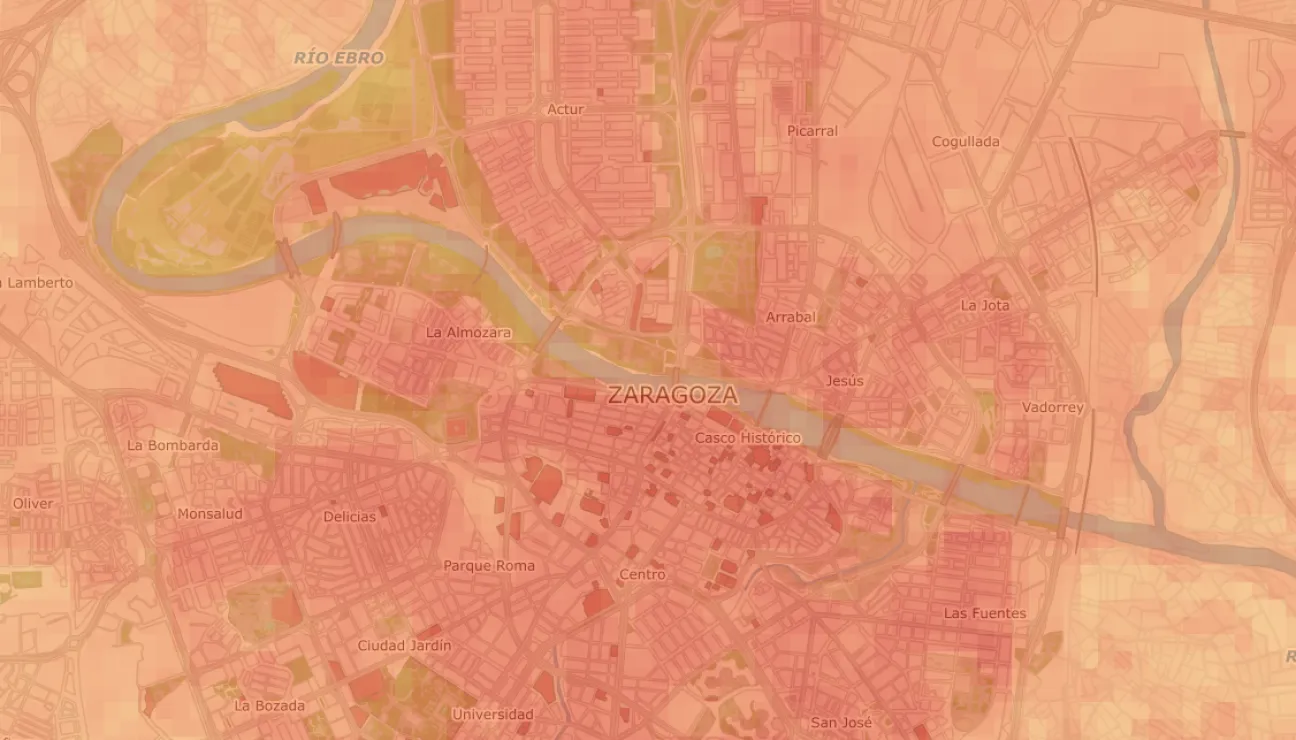
Some cities have already developed public tools to visualize these thermal patterns. One example is the Zaragoza City Council’s urban heat island viewer, which allows users to explore the spatial distribution of heat across the city based on geographic data.
Tools like these make it easier to identify which neighborhoods or urban spaces require priority intervention from a climate adaptation perspective.
Outdoor Thermal Comfort: Why Temperature Alone Is Not Enough
When analyzing urban heat, air temperature is usually the most visible indicator. However, temperature alone does not determine how people perceive the thermal environment of an outdoor space.
Outdoor thermal comfort depends on multiple variables that interact with one another. Direct solar radiation, wind speed, humidity, and surface temperatures all significantly influence the thermal sensation experienced by people.
For example, two squares may record the same air temperature but offer very different thermal conditions if one includes trees, shaded areas, or greater natural ventilation.
To evaluate these conditions, thermal comfort indices are used that integrate different environmental variables. One of the most widely used in urban microclimate studies is the UTCI (Universal Thermal Climate Index), which estimates the level of thermal stress experienced by people outdoors.
These indicators are particularly useful for answering a key question in urban planning: whether a public space can be used comfortably during a heat wave.
Detecting Urban Heat: City-Scale Analysis
Before designing specific interventions, cities need to understand how heat is distributed across their territory. This diagnosis is carried out through city-scale climate analysis, combining different sources of information.
Satellite imagery, geographic information systems (GIS), and urban sensor networks make it possible to identify thermal patterns, detect areas with limited vegetation, or locate zones where surface temperatures are especially high.

The goal of this analysis is not yet to implement specific solutions, but rather to identify the parts of the city where interventions could generate the greatest impact in terms of climate adaptation.
Urban Microclimate Modelling: Simulating Solutions Before Acting
Once heat-vulnerable areas have been identified, the next step is to analyze how different urban interventions could modify the local microclimate.
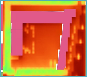
For this purpose, advanced urban microclimate modelling tools are used, such as Computational Fluid Dynamics (CFD) simulations or microclimate models like ENVI-met. These tools make it possible to digitally recreate the thermal behavior of a specific urban space.
Through these simulations, it is possible to analyze how factors such as vegetation, urban materials, or building geometry influence people’s thermal comfort.
This approach allows different scenarios to be compared before carrying out a physical intervention in the urban space, reducing uncertainty and enabling more data-driven decision-making.
Climate Adaptation of Schoolyards: The CARDIMED Project
An example of this approach is the European project CARDIMED, funded by the Horizon Europe programme and focused on developing nature-based solutions (NbS) for climate adaptation in Mediterranean regions.
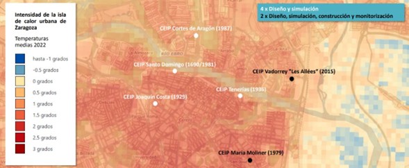
In Aragón, CARDIMED includes a pilot project aimed at improving resilience to heat waves in schoolyards through renaturalization and spatial redesign interventions.
Schoolyards are environments particularly sensitive to urban heat. During the warmest months, they can reach high temperatures that affect the well-being and health of students.
The work carried out in this project follows several stages. First, schools located in areas of Zaragoza with the highest urban heat island intensity were identified. Microclimate simulations were then conducted to evaluate existing thermal conditions and analyze possible interventions.
Based on these analyses, nature-based solutions were designed, including the incorporation of vegetation, the creation of shaded areas, and the use of materials with lower heat accumulation. These interventions are complemented by environmental monitoring systems that measure temperature and humidity before and after implementation.
Designing Cities That Are More Resilient to Heat
Urban climate adaptation requires combining diagnosis, simulation, and monitoring in order to design truly effective interventions. Cities that integrate these tools can better understand how heat is distributed across their territory, evaluate different solutions before implementing them, and measure the real impact of interventions once they are carried out.
At CIRCE, we work with public administrations and urban stakeholders to analyze the thermal behavior of cities, develop urban microclimate models, and evaluate data-driven climate adaptation strategies.
If you would like to learn how we can help analyze the impact of urban heat or design solutions to improve thermal comfort in urban spaces, you can contact our technical team.
You can also explore other content on our blog related to sustainable mobility and resilient urban planning.
Latest news